


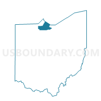
004 PORT CLINTON 2B, Ottawa County, Ohio
About
Outline

Summary
| Unique Area Identifier | 650854 |
| Name | 004 PORT CLINTON 2B |
| County | Ottawa County |
| State | Ohio |
| Area (square miles) | 0.23 |
| Land Area (square miles) | 0.23 |
| Water Area (square miles) | 0.00 |
| % of Land Area | 100.00 |
| % of Water Area | 0.00 |
| Latitude of the Internal Point | 41.50353110 |
| Longtitude of the Internal Point | -82.94299630 |
Maps


Graphs
Select a template below for downloading or customizing gragh for 004 PORT CLINTON 2B, Ottawa County, Ohio


Neighbors
Neighoring Voting District (by Name) Neighboring Voting District on the Map
- 001 PORT CLINTON 1A, Ottawa County, OH
- 002 PORT CLINTON 1B, Ottawa County, OH
- 003 PORT CLINTON 2A, Ottawa County, OH
- 005 PORT CLINTON 3A, Ottawa County, OH
- 006 PORT CLINTON 3B, Ottawa County, OH
- 037 PORTAGE 1, Ottawa County, OH
Top 10 Neighboring County Subdivision (by Population) Neighboring County Subdivision on the Map
Top 10 Neighboring Place (by Population) Neighboring Place on the Map
Top 10 Neighboring Unified School District (by Population) Neighboring Unified School District on the Map
Top 10 Neighboring State Legislative District Lower Chamber (by Population) Neighboring State Legislative District Lower Chamber on the Map
Top 10 Neighboring State Legislative District Upper Chamber (by Population) Neighboring State Legislative District Upper Chamber on the Map
Top 10 Neighboring 111th Congressional District (by Population) Neighboring 111th Congressional District on the Map
Top 10 Neighboring Census Tract (by Population) Neighboring Census Tract on the Map
- Census Tract 512, Ottawa County, OH (3,520)
- Census Tract 506, Ottawa County, OH (3,293)
- Census Tract 505, Ottawa County, OH (3,213)